
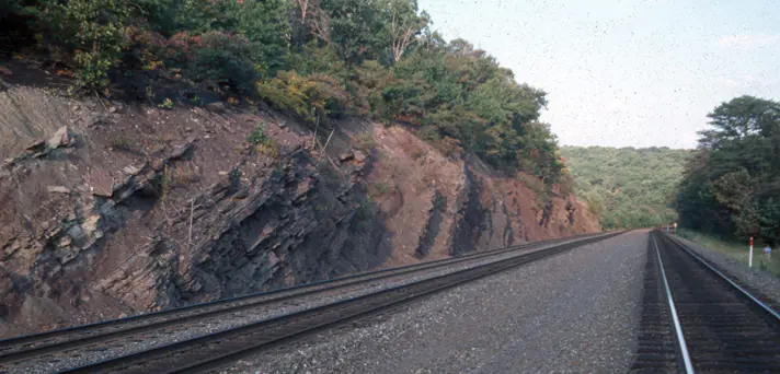

Where is the Catskill Formation?
Catskill-named rocks occur through Pennsylvania and adjoining New York, Maryland, and West Virginia. They form ridges, plateaus, and red-soil lowlands depending on sandstone content and structural position.
Dozens of regional members divide the formation, and some surveys use Catskill as part of a larger group or red-bed interval. The base and top can also shift in age as river and marine facies intertongue across the basin.
How did it form?
Rivers flowing from the Acadian highlands spread sand and mud across broad floodplains and deltas. Channel sandstone, overbank siltstone, floodplain shale, and local conglomerate record repeated migration of those river systems.
Oxidation of iron in well-drained sediment produced the characteristic red color, while gray-green beds mark different groundwater or depositional conditions. Rapid sediment supply limited marine influence across much of the red-bed tract.
Fossil record
Plant fragments, fossil wood, fish remains, and freshwater or brackish-water organisms occur locally. Some beds are nearly barren, while transitional intervals closer to marine strata can preserve a more varied fauna.
The scarcity of fossils in many red beds is meaningful but not absolute. Oxidizing floodplain soils and energetic channels were generally less favorable for preservation than quiet ponds or marginal-water settings.
Compare observable anatomy in the fossil identification guides, then review the U.S. fossil collecting-law guide before disturbing any find. A formation-level record does not prove a fossil is present, exposed, common, or legal to collect at a particular place.
Minerals and geological resources
Quartz is abundant in sandstone, with feldspar, mica, and clay minerals in finer beds. Hematite and related iron oxides create red pigmentation; calcite or silica may cement resistant sandstone.
Quartz pebbles are common in conglomeratic members. The unit is not uniformly mineralized, and red color alone does not indicate an iron-ore deposit.
Identify rocks and minerals named in this guide
Use physical properties to investigate materials discussed above. A formation name or mapped location supports context, but it cannot identify a hand sample by itself.
What to know in the field
- Member names and the Catskill–Chemung transition differ across the Appalachian Basin.
- Sandstone ledges can overhang softer shale and release blocks along joints.
- Red soil or float rock is not sufficient for a formation identification without bedrock context.
Formation, fossil, and mineral information is educational. It does not establish land ownership, legal access, collecting permission, specimen identity, or present-day field conditions.
Authoritative sources
This guide synthesizes the following sources in original language. Consult the linked records for local stratigraphic detail and the underlying scientific literature.
- Geolex Catskill unit record U.S. Geological Survey
- Catskill depositional interpretation and regional geology U.S. Geological Survey
Editorial review: September 16, 2026.