

Where is the Chinle Formation?
Chinle rocks crop out widely across the Colorado Plateau and neighboring regions. The name is used at formation rank in many areas and at group rank in others, particularly where geologists divide the succession into several formations.
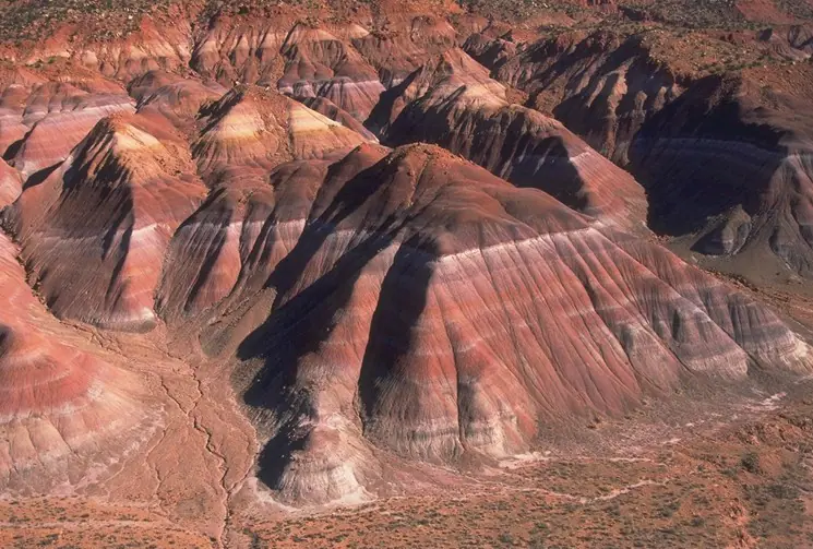
Its cliffs, slopes, and painted badlands vary by member. Resistant sandstone and conglomerate commonly trace former channels, while red, purple, gray, and green mudstones form softer slopes. The Petrified Forest Member is only one part of this complex succession.
How did it form?
Large river systems carried sediment across a broad continental basin. Channels shifted across floodplains dotted with ponds, lakes, and wetlands. Volcanic ash mixed with floodplain mud and later altered to clay, contributing to both the unit’s colors and its unstable, swelling slopes.
Regional differences in source area, river style, and basin position produced many named members. Contacts and terminology have also changed through scientific study, so current state and federal maps should guide local usage.
Fossil record
Petrified conifer wood is the signature fossil, locally preserving growth rings and cellular structure. The formation also contains other plant remains, pollen, fish, amphibians, reptiles, early dinosaurs, and crocodile-line archosaurs such as phytosaurs and aetosaurs.
Fossil abundance is member- and locality-specific. Mineral replacement turned some buried logs to stone, but most wood decayed. Even inside a famous fossil-bearing unit, a particular exposure may contain no visible fossils.
Compare observable anatomy in the fossil identification guides, then review the U.S. fossil collecting-law guide before disturbing any find. A formation-level record does not prove a fossil is present, exposed, common, or legal to collect at a particular place.
Minerals and geological resources
Quartz is abundant in sandstone and in much petrified wood; chalcedony is a common microcrystalline form of silica in silicified logs. Iron oxides and hydroxides contribute red, yellow, and brown colors, while manganese oxides can add darker tones.
Clay minerals are abundant in mudstone and altered ash. Uranium and copper mineralization occurs locally in channel sandstones and has supported historic mining districts, but it is highly localized and can create radiation, contamination, and abandoned-mine hazards.
Identify rocks and minerals named in this guide
Use physical properties to investigate materials discussed above. A formation name or mapped location supports context, but it cannot identify a hand sample by itself.
What to know in the field
- Chinle mudstone can be impassable when wet and can fail as swelling clay beneath roads or trails.
- Petrified wood is protected in national parks and may be restricted on other public lands; confirm the exact land manager’s rule.
- Do not enter historic uranium workings or handle unknown mine waste.
Formation, fossil, and mineral information is educational. It does not establish land ownership, legal access, collecting permission, specimen identity, or present-day field conditions.
Authoritative sources
This guide synthesizes the following sources in original language. Consult the linked records for local stratigraphic detail and the underlying scientific literature.
- Geolex Chinle unit record U.S. Geological Survey
- Geolex Chinle references U.S. Geological Survey
- Secrets of the Chinle Formation National Park Service
Editorial review: September 16, 2026.