

Where is the Hell Creek Formation?
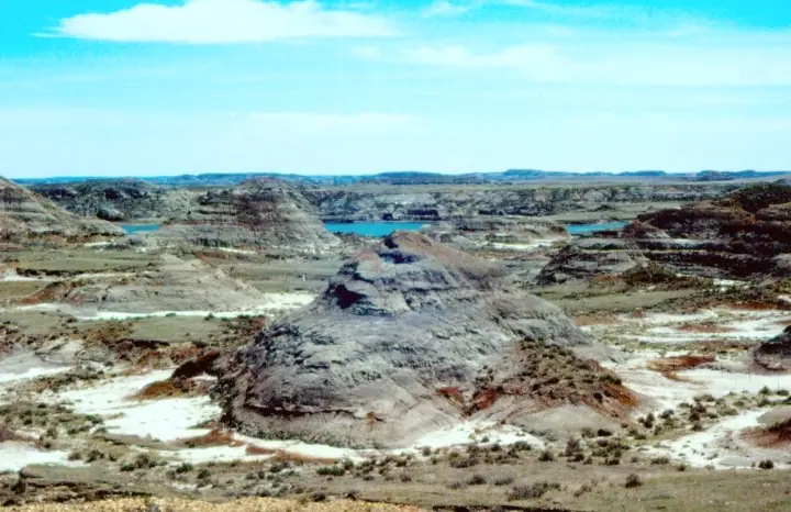
The formation is best exposed in eastern Montana and the western Dakotas, with recognized use extending into Wyoming. Badlands reveal stacked channels and floodplain deposits, while the unit continues beneath younger cover over a broader area.
Its upper boundary lies near the Cretaceous–Paleogene transition, but local exposures can be incomplete. Correctly locating that boundary requires stratigraphic evidence; a color change or isolated fossil alone is not sufficient.
How did it form?
Sandstone bodies mark former river channels and bars. Finer claystone and siltstone settled on floodplains and in abandoned channels, while thin lignite beds formed from plant material in wet, poorly drained settings. Bentonite records altered volcanic ash, and siderite concretions or nodules occur locally.
The landscape shifted repeatedly as channels migrated. That patchwork explains why fossils can be dense at one horizon and scarce a short distance away: preservation depended on the local environment and the timing of burial.
Fossil record
Hell Creek is renowned for Tyrannosaurus, Triceratops, Edmontosaurus, and other dinosaurs. Its broader ecosystem also included fish, turtles, crocodilians, mammals, lizards, amphibians, mollusks, and an extensive plant record preserved as leaves, wood, pollen, and spores.
Fossil assemblages extend close to the end-Cretaceous boundary, but the uppermost fine-grained beds can be poor in fossils where channel deposits are absent. Scientific surveys therefore distinguish ecological change from gaps caused by preservation and exposure.
Compare observable anatomy in the fossil identification guides, then review the U.S. fossil collecting-law guide before disturbing any find. A formation-level record does not prove a fossil is present, exposed, common, or legal to collect at a particular place.
Minerals and geological resources
Quartz and feldspar dominate many sandstones; clay minerals make up much of the finer rock. Calcite and iron-carbonate minerals can cement concretions, and siderite nodules are locally common. Altered ash contributes bentonitic clay.
Thin lignite seams occur in some areas. Lignite is an organic sedimentary rock, not a mineral, but it is geologically important because it records wet, vegetation-rich environments and may influence groundwater chemistry and slope stability.
Identify rocks and minerals named in this guide
Use physical properties to investigate materials discussed above. A formation name or mapped location supports context, but it cannot identify a hand sample by itself.
What to know in the field
- Badlands erode quickly, so maps and exposures can change after storms.
- Dinosaur and other vertebrate fossils on federal land may not be collected without the appropriate research permit.
- Private ranchland is extensive throughout the region; visible outcrop does not imply public access.
Formation, fossil, and mineral information is educational. It does not establish land ownership, legal access, collecting permission, specimen identity, or present-day field conditions.
Authoritative sources
This guide synthesizes the following sources in original language. Consult the linked records for local stratigraphic detail and the underlying scientific literature.
- Geolex Hell Creek unit record U.S. Geological Survey
- Vertebrate biostratigraphy of the Hell Creek Formation U.S. Geological Survey
- Hell Creek depositional ages study U.S. Geological Survey
Editorial review: September 16, 2026.