
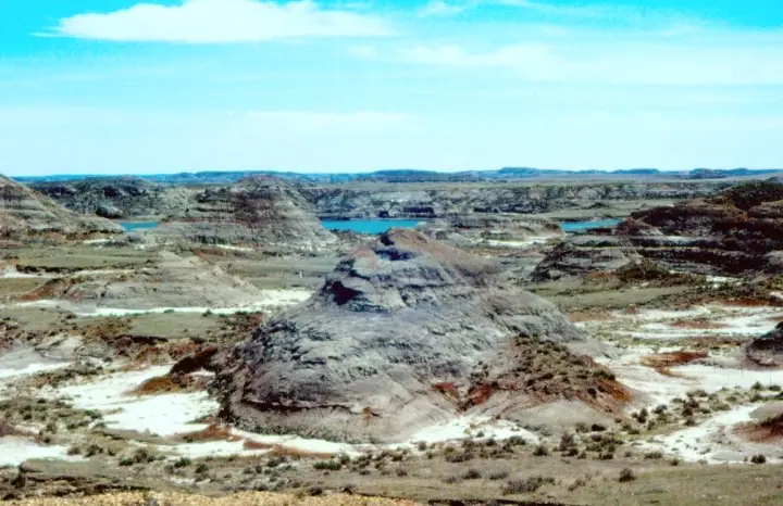

Major geologic regions of Montana
Western mountain belts
Accreted terranes, metamorphic and igneous rocks, thrust systems, batholiths, and mineralized districts create complex geology from the Idaho border through the northern Rockies.
Southwestern uplifts and basins
Archean basement, younger sedimentary cover, volcanic fields, fault-bounded valleys, and Laramide structures expose a long record around the Beartooth, Tobacco Root, and adjacent ranges.
Disturbed Belt and Rocky Mountain Front
Thrust faults and folds stack and repeat Paleozoic and Mesozoic strata along the abrupt transition from mountains to plains.
Central and eastern plains and basins
Sedimentary rock and younger glacial or river deposits underlie broad plains, badlands, coal fields, and basins such as the Williston and Powder River systems.
Geologic history
Montana’s oldest exposed rocks include Archean crystalline crust in the southwest and younger Proterozoic sedimentary successions in the northwest. Paleozoic seas deposited carbonate, sandstone, and shale across broad shelves, with erosion interrupting the record at several times.
Mesozoic marine and continental environments alternated as the Western Interior Seaway advanced and retreated. Sediment accumulated in coastal plains, rivers, floodplains, and offshore basins. Late Cretaceous Hell Creek deposits preserve ecosystems near the end of dinosaur time in eastern Montana.
Sevier and Laramide deformation folded, faulted, and uplifted western and central Montana. Cenozoic volcanism, intrusion, basin sedimentation, and erosion followed. Pleistocene alpine and continental glaciers carved western valleys and spread drift across the northern plains, while modern rivers continue excavating badlands and terraces.
Common and significant rocks and minerals
Gneiss, schist, granite, and batholithic rock
Ancient basement and younger intrusions dominate parts of western and southwestern Montana.
Limestone, sandstone, and shale
Paleozoic and Mesozoic strata form mountain fronts, plains, fossil beds, aquifers, and hydrocarbon-bearing basins.
Copper, molybdenum, gold, silver, lead, zinc, and manganese minerals
Intrusions and hydrothermal systems created major districts including Butte. Historic workings and contaminated mine lands require caution.
Coal and bentonite
Eastern basins contain extensive coal, while altered volcanic ash produced bentonite in particular Cretaceous units.
Agate, sapphire, petrified wood, and other collectible materials
Famous materials occur in restricted deposits or transported gravel. Appearance alone cannot prove locality, quality, access, or value.
A statewide occurrence does not mean a material is present, collectible, or economically valuable at a particular location. Confirm the mapped unit, land status, and applicable rules.
Fossil record
Montana preserves marine invertebrates, fish, dinosaurs, mammals, plants, and trace fossils across a broad time range. Hell Creek badlands are famous for Tyrannosaurus and Triceratops, while older Cretaceous strata record the Western Interior Seaway.
Eastern badland exposures can make fossils look abundant, but scientifically useful material remains tied to exact horizons. Vertebrate fossils on federal land require permits, and collecting is prohibited in national parks and many protected areas.
Use the fossil identification guides to compare anatomy and preservation, and check the collecting-law guide before touching or moving a find. Statewide fossil history does not establish site-level presence, ownership, access, or permission.
Groundwater and geologic hazards
Groundwater occurs in fractured mountain rock, carbonate and sandstone aquifers, basin sediment, glacial deposits, and river alluvium. Coal, petroleum, evaporites, mine districts, and natural mineralization can influence water chemistry.
Landslides, rockfall, earthquakes, abandoned mines, mine-waste contamination, swelling soil, flooding, wildfire-related erosion, and severe winter exposure vary across the state. Glacial and landslide deposits can conceal bedrock contacts.
Field notes and limitations
- Large distances, limited service, wildfire, cold, heat, and rapidly changing weather are fundamental field risks.
- Badland slopes and bentonitic clay become extremely slick when wet.
- Respect tribal sovereignty, private ranchland, claims, active mines, and protected fossil localities.
- Do not infer a Hell Creek identification from an isolated dinosaur fossil or gray-green mudstone alone.
This guide is educational. It is not a legal boundary, access determination, mineral-rights opinion, professional hazard assessment, water-well evaluation, or collecting authorization.
Authoritative state geology sources
LithoMap wrote this guide in original language from the broad patterns supported by these state geological-survey and agency resources.
- The Geology of Montana Montana Bureau of Mines and Geology
- Montana geology framework data Montana State Library and Montana Bureau of Mines and Geology
- About the Montana Bureau of Mines and Geology Montana Bureau of Mines and Geology
Editorial review: September 17, 2026.