
_7_(38417957134).jpg)
Major geologic regions of Kansas
Eastern cuestas, lowlands, and Flint Hills
Alternating limestone, shale, and sandstone create stepped ridges, broad lowlands, and chert-capped tallgrass country. Pennsylvanian and Permian strata record repeated advances and retreats of shallow seas.
Smoky Hills and Red Hills
Cretaceous sandstone, shale, and chalk shape the Smoky Hills, while Permian red beds, gypsum, and salt influence the Red Hills farther south. Erosion emphasizes contrasts in rock resistance.
High Plains
Neogene sediment shed from the Rocky Mountains covers much of western Kansas. These deposits support the High Plains aquifer system, but thickness, grain size, and groundwater conditions vary.
Glaciated and river lowlands
Continental ice reached northeastern Kansas, leaving till and transported boulders. Younger alluvium forms flat lowlands along the Arkansas and other rivers.
Geologic history
Most exposed Kansas bedrock is sedimentary. Mississippian carbonate rocks appear in the extreme southeast; younger Pennsylvanian and Permian limestone, shale, sandstone, evaporites, and red beds crop out progressively westward. Repeated marine flooding generated many thin, laterally persistent layers.
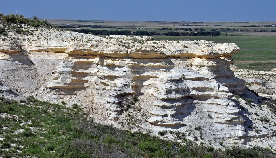
During the Cretaceous, the Western Interior Seaway covered western Kansas. Sand accumulated near changing shorelines, while offshore mud and carbonate-rich microscopic remains formed shale and chalk. The Niobrara record includes marine reptiles, fish, shells, and other organisms, but fossil abundance varies by bed.
After the sea withdrew, rivers carried sediment east from the rising Rockies. Ogallala and related High Plains deposits buried older strata. Later volcanic ash falls, loess, dunes, Pleistocene glaciation in the northeast, and modern rivers added a complex mantle of unconsolidated material.
Common and significant rocks and minerals
Limestone, shale, and chert
Marine cycles dominate eastern and central Kansas. Chert-rich limestone resists erosion in the Flint Hills.
Chalk
Soft Cretaceous carbonate rock forms prominent western bluffs and badlands; it is not ordinary construction limestone.
Gypsum and salt
Permian evaporite deposits underlie parts of central and southern Kansas and have influenced mining, subsidence, and groundwater chemistry.
Sand and gravel
High Plains and river deposits are major construction and aquifer materials, but a loose deposit is not a named bedrock formation.
Calcite, pyrite, and barite
These occur locally in sedimentary rocks and concretions. Attractive specimens do not by themselves identify the host unit.
A statewide occurrence does not mean a material is present, collectible, or economically valuable at a particular location. Confirm the mapped unit, land status, and applicable rules.
Fossil record
Eastern Paleozoic rocks contain brachiopods, bryozoans, crinoids, corals, mollusks, and other marine fossils. Cretaceous western strata preserve fish, ammonites, inoceramid clams, marine reptiles, birds, and occasional terrestrial material carried into the sea.
Younger High Plains deposits preserve mammals and other terrestrial fossils in selected localities. Scientific value depends strongly on precise layer and location, so moving a specimen can erase important context.
Use the fossil identification guides to compare anatomy and preservation, and check the collecting-law guide before touching or moving a find. Statewide fossil history does not establish site-level presence, ownership, access, or permission.
Groundwater and geologic hazards
Kansas groundwater comes from High Plains sediment, river-valley alluvium, and bedrock aquifers. Aquifer names describe broad systems; a productive or safe well depends on local thickness, recharge, pumping, and chemistry.
Relevant hazards include river flooding, erosion, drought-related groundwater decline, collapsible or expansive soil, abandoned mines, karst or evaporite dissolution, and localized induced or natural seismicity. Use current agency information for decisions.
Field notes and limitations
- Roadcuts, quarries, and pasture exposures require permission and traffic awareness.
- Chalk cliffs and undercut streambanks can collapse without warning.
- Glacial erratics may be far from their bedrock source.
- Record the layer and setting of a fossil; appearance alone cannot establish age.
This guide is educational. It is not a legal boundary, access determination, mineral-rights opinion, professional hazard assessment, water-well evaluation, or collecting authorization.
Authoritative state geology sources
LithoMap wrote this guide in original language from the broad patterns supported by these state geological-survey and agency resources.
- Physiographic Regions Kansas Geological Survey / GeoKansas
- Generalized Physiographic Map of Kansas Kansas Geological Survey
- Rocks, Minerals, and Fossils of Kansas Kansas Geological Survey
Editorial review: September 17, 2026.